Radar Geolitix RADAR Post Processing Software

#120009
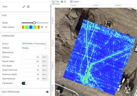
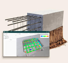
Geolitix is a continually-evolving cloud-based platform for the analysis of near-surface geophysical datasets to enable rapid, accurate data delivery for projects of any size. Users can drag-and-drop large datasets from any GPR instrument using any computer or tablet into a Geolitix workspace. Teams can collaborate in real time from acquisition through analysis and data sharing. Simplified data analysis for buried utilities mapping, rebar and bridge deck analysis, forensics and archaeology, pavement and railbed imaging, geological mapping and drone GPR. GPS, traditional grid and complex geometry single and multichannel projects can be imported and analysed easily. No additional modules needed for bridge deck or multichannel projects.
N/A inches
N/A lbs
$100.00
$0.00
$0.00
Ask a question about this item
*(Does not include shipping or insurance)